
Tanger, Safi, Ceuta, Arzilla and Sale, by Georg Braun and Frans Hogenberg. 1582
Braun G. & Hogenberg F. and the Civitates Orbis Terrarum.
The Civitates Orbis Terrarum, or the "Braun & Hogenberg", is a six-volume town atlas and the most excellent book of town views and plans ever published: 363 engravings, sometimes beautifully coloured. It was one of the best-selling works in the last quarter of the 16th century. Georg Braun wrote the text accompanying the plans and views on the verso. Many plates were engraved after the original drawings of a professional artist, a professional artist, Joris Hoefnagel (1542-1600). The first volume was published in Latin in 1572, and the sixth in 1617. Frans Hogenberg created the tables for volumes I through IV, and Simon van den Neuwel made those for volumes V and VI. Other contributors were cartographers Daniel Freese and Heinrich Rantzau. Works by Jacob van Deventer, Sebastian Münster, and Johannes Stumpf were also used. Translations appeared in German and French.
Following the original publication of Volume 1 of the Civitates in 1572, seven further editions of 1575, 1577, 1582, 1588, 1593, 1599 and 1612 can be identified. Vol.2, first issued in 1575, was followed by further editions in 1597 and 1612. The subsequent volumes appeared in 1581, 1588, 1593, 1599 and 1606. The German translation of the first volume appeared from 1574 on, and the French edition from 1575 on.
Several printers were involved: Theodor Graminaeus, Heinrich von Aich, Gottfried von Kempen, Johannis Sinniger, Bertram Buchholtz and Peter von Brachel, who all worked in Cologne.
Georg Braun (1541-1622)
Georg Braun was born in Cologne in 1541. After his studies in Cologne, he entered the Jesuit Order as a novice. 1561, he obtained his bachelor's degree, and in 1562, he received his Magister Artium. Although he left the Jesuit Order, he studied theology, gaining a licentiate in theology.
Frans Hogenberg (1535-1590)
Frans Hogenberg was a Flemish and German painter, engraver, and mapmaker. He was born in Mechelen as the son of Nicolaas Hogenberg.
By the end of the 1560s, Frans Hogenberg was employed upon Abraham Ortelius's Theatrum Orbis Terrarum, published in 1570; he is named an engraver of numerous maps. In 1568, he was banned from Antwerp by the Duke of Alva and travelled to London, where he stayed a few years before emigrating to Cologne. He immediately embarked on his two most important works, the Civitates, published in 1572 and the Geschichtsblätter, which appeared in several series from 1569 until about 1587.
Thanks to large-scale projects like the Geschichtsblätter and the Civitates, Hogenberg's social circumstances improved with each passing year. He died as a wealthy man in Cologne in 1590.
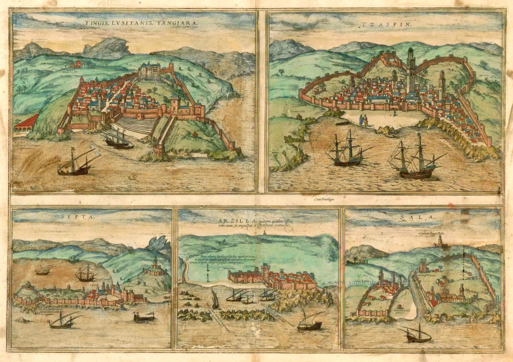
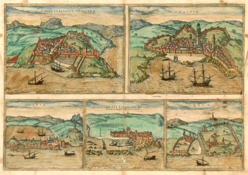
Tingis Lusitanis Tangiara [on sheet with] Tzaffin [and] Septa [and] Arzilla [and] Sala
Item Number: 24693 Authenticity Guarantee
Category: Antique maps > Africa
Antique map with five bird's-eye views by Braun and Hogenberg: Tanger, Safi, Ceuta, Arzilla and Sale.
TANGIER (TANJA)
COMMENTARY BY BRAUN: "Tingis, which the Portuguese call Tanigara, is a large and ancient city, situated not far from the western Mediterranean. At the time when the Goths ruled over Granada it was under the rule of the chief of the city of Septa [Ceuta], until Arzilla [Asilah] was brought under the rule of the Muslims; it has always been beautifully adorned, noble and very well built with many splendid works of architecture."
The engraving shows a fortified town, whereby only half the area within the walls is built up. The large building in the background may be the governor's residence. In 1471 the Portuguese attacked Asilah, whose inhabitants fled to Tangier. But that same year Tangier, too, was conquered, and remained in Potuguese hands until 1580. Tangier today belongs to Morocco and has a population of 670,000.
SAFI
COMMENTARY BY BRAUN: "Tzaffin is a small town in Africa that is surrounded by mountains and a wall. It possesses a castle fortified with numerous turrets, many handsome houses and an extremely tall tower. This town was taken from the Moors in 1508 by King Manuel's commander-in-chief."
CEUTA
COMMENTARY BY BRAUN: "Ceuta, called Seupta by the Portuguese, was built by the Romans on the shores of the Sea of Hercules and was formerly the capital of Mauretania, which is why the Romans regarded it so highly. It was later taken by the Goths and a prince was installed, under whose rule it remained until the Muslims came to Mauretania and subjugated this city too."
The engraving shows that only a small promontory in the north of the peninsula was inhabited. Ceuta, which measures 18 sq. km, lies on a peninsula on the coast of North Africa, near the Strait of Gibraltar. There were three reasons for its conquest by Portugal in 1415: firstly, the peninsula had become a threat due to its location on the Strait of Gibraltar, where it could potentially provide the Muslims with a stepping-stone to Europe. Secondly, Ceuta was an important trading port via which goods from Africa, in particular gold, were brought to Europe. Thirdly, the peninsula offered Portugal a gateway to the unknown continent of Africa. Part of Spain since 1668, the autonomous city of Ceuta is today home to 4,000 inhabitants.
ASILAH
TRANSLATION OF CAPTION: Asilah, formerly the largest city in Africa, is today confined within the narrowest bounds by the Christians.
COMMENTARY BY BRAUN: "The city was rebuilt at the time of Bishop Cardova, who then reigned over Mauretania; it grew in prosperity and became stronger. The inhabitants were rich, educated and well-armed people. The land around the city is fertile and all sorts of cereals and vegetables can be easily cultivated."
The entry on Asilah contains accurate information about the city's history and illustrates, for example, the difficult entrance to its harbour. Founded by the Romans under the name of Zilias, in the Middle Ages the town provided an important strategic base for the Portuguese, who wanted to penetrate deeper into the continent from here. They held the city between 1471 and 1541 and occupied it from 1577 to 1589.
SALÉ
COMMENTARY BY BRAUN: "Two towns are called Sala, one New Sala, the other Old Sala: they are separated by a river. They lie not far from the Sea of Hercules and Septa [Ceuta]. In 1514 Old Sala expanded substantially with many buildings and in trade. It has a large castle and tower of great height, called Summatesse [Hasan tower], which the Saracens built solely so that they could see across to Granada."
The two settlements are depicted on either side of the river overlooking the sea. There are strikingly few houses within either city wall and no harbour facilities. Higher up the hillside rises the 44-m-high Hasan tower. Salé in Morocco is separated from its twin city of Rabat by the Bou-Regreg River. The New Sala (Sala nova) mentioned in Braun's text refers to modern-day Salé, and the Old Sala (Sala vetus) to Rabat, the political capital of Morocco. (Taschen)
Date of the first edition: 1572
Date of this map: 1582
Copper engraving
Size: 33 x 48cm (12.9 x 18.7 inches)
Verso text: German
Condition: Contemporary old coloured, age-toned, stained, offsetting.
Condition Rating: B
References: Van der Krogt 4, 4253; Taschen, Braun and Hogenberg, p.123.
From: Beschreibung und Contrafactur der vornembster Stät der Welt. [Part 1] Cologne, Gottfried von Kempen, 1582. (Van der Krogt 4, 41:2.1)
Braun G. & Hogenberg F. and the Civitates Orbis Terrarum.
The Civitates Orbis Terrarum, or the "Braun & Hogenberg", is a six-volume town atlas and the most excellent book of town views and plans ever published: 363 engravings, sometimes beautifully coloured. It was one of the best-selling works in the last quarter of the 16th century. Georg Braun wrote the text accompanying the plans and views on the verso. Many plates were engraved after the original drawings of a professional artist, a professional artist, Joris Hoefnagel (1542-1600). The first volume was published in Latin in 1572, and the sixth in 1617. Frans Hogenberg created the tables for volumes I through IV, and Simon van den Neuwel made those for volumes V and VI. Other contributors were cartographers Daniel Freese and Heinrich Rantzau. Works by Jacob van Deventer, Sebastian Münster, and Johannes Stumpf were also used. Translations appeared in German and French.
Following the original publication of Volume 1 of the Civitates in 1572, seven further editions of 1575, 1577, 1582, 1588, 1593, 1599 and 1612 can be identified. Vol.2, first issued in 1575, was followed by further editions in 1597 and 1612. The subsequent volumes appeared in 1581, 1588, 1593, 1599 and 1606. The German translation of the first volume appeared from 1574 on, and the French edition from 1575 on.
Several printers were involved: Theodor Graminaeus, Heinrich von Aich, Gottfried von Kempen, Johannis Sinniger, Bertram Buchholtz and Peter von Brachel, who all worked in Cologne.
Georg Braun (1541-1622)
Georg Braun was born in Cologne in 1541. After his studies in Cologne, he entered the Jesuit Order as a novice. 1561, he obtained his bachelor's degree, and in 1562, he received his Magister Artium. Although he left the Jesuit Order, he studied theology, gaining a licentiate in theology.
Frans Hogenberg (1535-1590)
Frans Hogenberg was a Flemish and German painter, engraver, and mapmaker. He was born in Mechelen as the son of Nicolaas Hogenberg.
By the end of the 1560s, Frans Hogenberg was employed upon Abraham Ortelius's Theatrum Orbis Terrarum, published in 1570; he is named an engraver of numerous maps. In 1568, he was banned from Antwerp by the Duke of Alva and travelled to London, where he stayed a few years before emigrating to Cologne. He immediately embarked on his two most important works, the Civitates, published in 1572 and the Geschichtsblätter, which appeared in several series from 1569 until about 1587.
Thanks to large-scale projects like the Geschichtsblätter and the Civitates, Hogenberg's social circumstances improved with each passing year. He died as a wealthy man in Cologne in 1590.
Related items
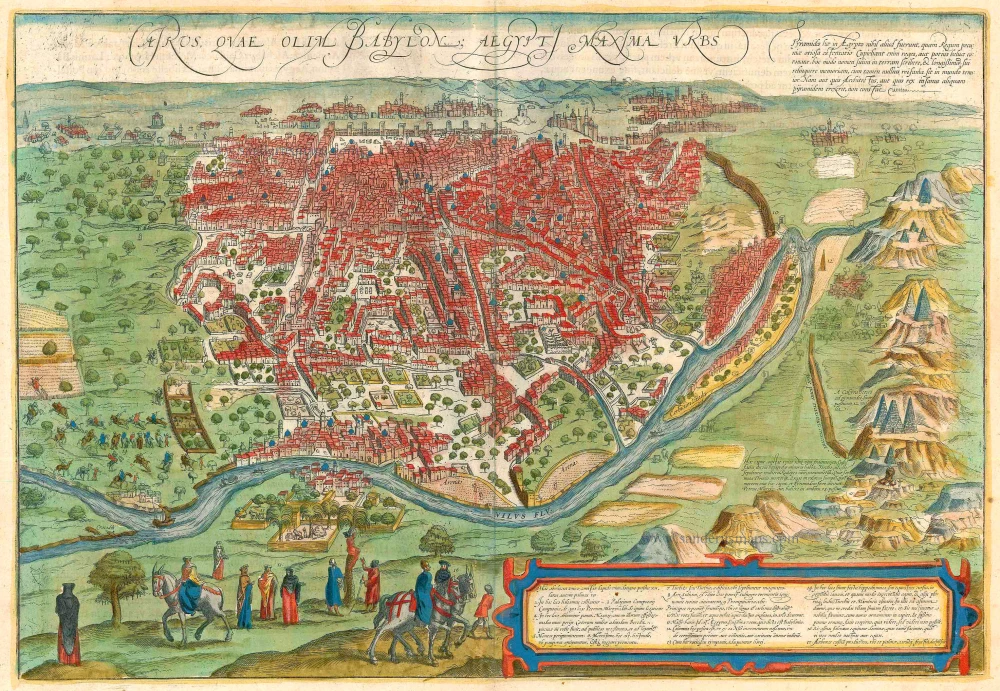
Cairus, quae olim Babylon; Aegypti Maxima Urbs. 1599
Cairo, by Georg Braun and Frans Hogenberg.
[Item number: 23244]
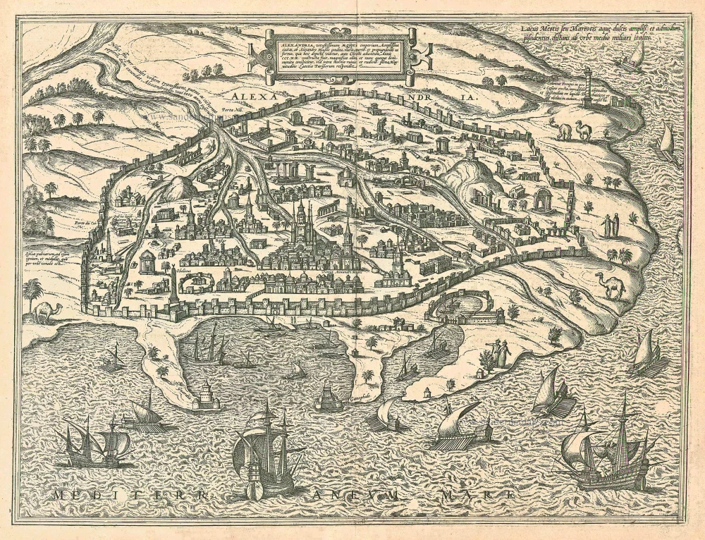
Alexandria, Vetustissimum Aegypti Emporium, Amplissima Civitas .Penon de Veles. 1597
Egypt - Alexandria by Georg Braun & Frans Hogenberg
[Item number: 24010]