
Magellan Straits & Tierra Del Fuego, by Johannes de Laet. 1630
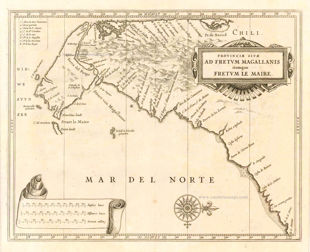
Considerable effort went into making the text and maps of this work the most accurate available at the time. It is arguably the finest description of the Americas published in the seventeenth century. The exhaustive research involved de Laet reading all of the published and manuscript material that he could find. For the cartographic work he had much to call on, being a director of the recently formed Dutch West India Company in charge of all Dutch interests in America and Africa. He therefore had access to the latest geographic knowledge. He also drew upon the fine talents of Hessel Gerritsz, the official cartographer to the Dutch East India Company since 1617. This was a post he attained before Willem Blaeu under whom he was apprenticed, and who was his senior by ten years.
The maps were some of the first to depart from the heavier style of the Mercator and Ortelius period. This more open style of engraving was one that both Blaeu and Janssonius would develop in their atlases. The first edition of the book in 1625 contained ten maps which concentrated on South America. Since then the Dutch had taken considerable interest in New Amsterdam (New York), and the work was expanded by some 100 pages and four newly engraved maps. (Burden)
Provinciae Sitae ad Fretum Magallanis itemque Fretum le Maire.
Item Number: 25391 Authenticity Guarantee
Category: Antique maps > America > South America
Old, antique map of Magellan Straits & Tierra Del Fuego by J. de Laet, oriented to the West
Cartographer: Hessel Gerritsz
Date of the first edition: 1625
Date of this map: 1630
Copper engraving
Size (not including margins): 28 x 36cm (10.9 x 14 inches)
Verso: Blank
Condition: Excellent.
Condition Rating: A+
From: Beschrijvinghe van West-Indien. Leiden, 1630.
Considerable effort went into making the text and maps of this work the most accurate available at the time. It is arguably the finest description of the Americas published in the seventeenth century. The exhaustive research involved de Laet reading all of the published and manuscript material that he could find. For the cartographic work he had much to call on, being a director of the recently formed Dutch West India Company in charge of all Dutch interests in America and Africa. He therefore had access to the latest geographic knowledge. He also drew upon the fine talents of Hessel Gerritsz, the official cartographer to the Dutch East India Company since 1617. This was a post he attained before Willem Blaeu under whom he was apprenticed, and who was his senior by ten years.
The maps were some of the first to depart from the heavier style of the Mercator and Ortelius period. This more open style of engraving was one that both Blaeu and Janssonius would develop in their atlases. The first edition of the book in 1625 contained ten maps which concentrated on South America. Since then the Dutch had taken considerable interest in New Amsterdam (New York), and the work was expanded by some 100 pages and four newly engraved maps. (Burden)
Related items

Caerte vande Landen vande Papouas ofte Nova Guinea nae de beseijlinge en ondecking van Iacob le Maire gedaen in den Iare 1616. / Tabula exhibens Papouarum seu Nova Guineae Regones ... / Cartes des Terres de Papouas ou de Guinee Neuve ... 1622
Chart of the route of Schouten and Le Maire north of New Guinea, and the Moluccas, by A. de Herrera, published by M. Colijn.
[Item number: 4165]

Caerte van de zeylage van Jacob le Maire over de Zuydzee, vertonende de Eylanden ende Landen aldaer by hem ghesien ende aenghedaen. / Tabula, ductum navigationis, quem in Mari Australi tenuit Iacobus Le Maire ... 1622
Rare chart showing the route taken by Schouten and le Maire from South America to New Guinea, by Michiel Colijn.
[Item number: 25104]
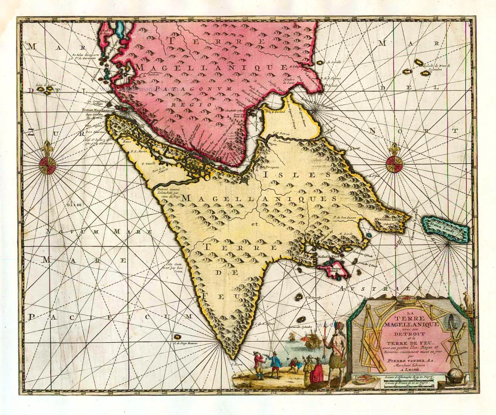
La Terre Magellanique avec son Détroit et la Terre de Feu, avec ses petites Iles, Bayes et Rivieres. 1713
Magellan Straits & Tierra del Fuego, by Pieter van der Aa.
[Item number: 26153]
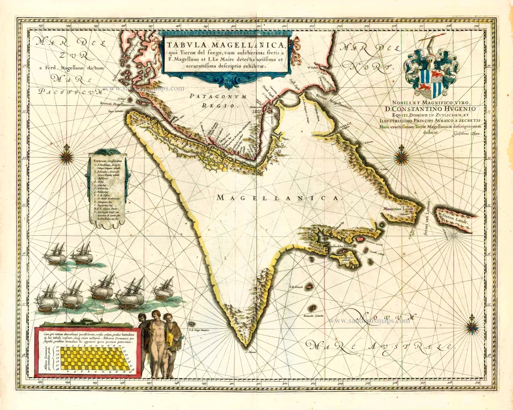
Tabula Magellanica, qua Tierrae del fuego, cum celeberrimis fretis a F. Magellano et I. Le Maire detectis ... 1640
Straits of Magellan, by Willem & Joan Blaeu.
[Item number: 27140]
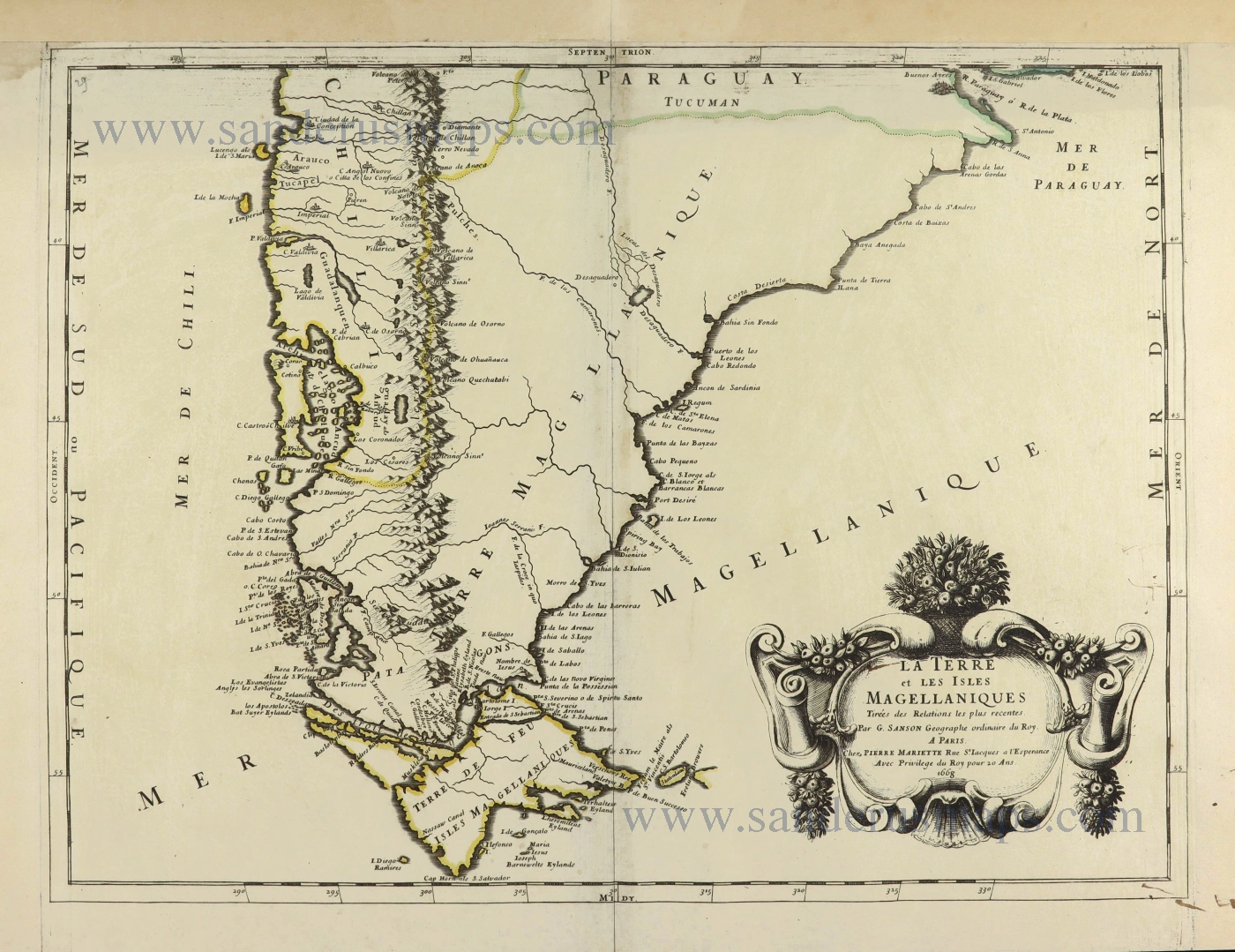
La Terre et les Isles Magellaniques. 1670
Southern South America with the Straits of Magellan, by Guillaume Sanson.
[Item number: 28510]

With luxury colour
Tabula Magellanica qua Tierrae del Fuego. 1653-66
Straits of Magellan by Joannes Janssonius.
[Item number: 29805]