
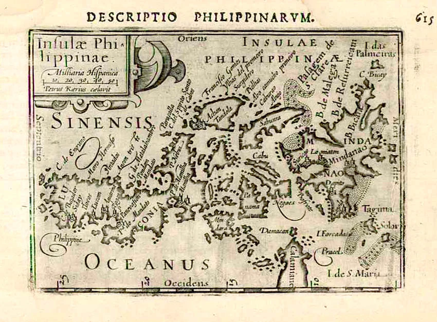
Old antique map of the Philippines, by Bertius Petrus. 1602
Petrus Bertius (1565-1629)
Petrus Bertius, born at Beveren, Flanders in 1565, was related with Pieter van den Keere (Kaerius) and Jodocus Hondius. Both famous cartographers were brothers-in-law of Petrus Bertius. As a refugee, he settled in Amsterdam and, after finishing his studies, he became professor of mathematics and librarian at the University of Leiden. In 1618 he also became cosmographer and historiographer to Louis XIII of France and lived in Paris, where he died in 1629.
His enormous working power resulted in many geographical and theological works. He also contributed geographic materials to the works of Clüver and Herrera.
His fame among geographers was established by his text in the pocket atlas Tabularum Geographicarum and by his edition of Ptolemy’s Geographia.
The origin of the Tabularum Geographicum lies in the well-know miniature atlas Caert thresoor, published by Barent Langenes in 1598 in Middelburg. Bertius engraved 169 maps for this small but attractive atlas which was also sold for the first time in 1599 by Cornelis Claesz in Amsterdam. In 1600, Claesz published the pocket atlas with a Latin text composed by Petrus Bertius. From then on, new editions, often enlarged with new maps, regularly appeared, subsequently published by Cornellis Claesz, Jodocus Hondius, Johannes Janssonius and ultimately, in 1649, by Claes Jansz. Visscher.
Koeman divides this series of pocketbooks into two atlases: The Caert-thresoor, published by Langenes and Claesz., with five editions between 1598 and 1609; and the Tabularum Geographicarum Contractarum by Petrus Bertius with ten editions between 1600 and 1650.
Insulae Philippinae.
Item Number: 26933 Authenticity Guarantee
Category: Antique maps > Asia > Southeast Asia
Old, antique map of the Philippines, by Petrus Bertius.
Oriented to the East.
Engraver: Petrus Kaerius (Pieter Van der Keere).
Date of the first edition: 1598
Date of this map: 1602
Copper engraving, printed on paper.
Size (not including margins): 9 x 12.5cm (3.5 x 4.9 inches)
Verso text: Latin
Condition: Light waterstained.
Condition Rating: A
References: Van der Krogt 3, 8580:341; Quirino, p.99.
From: BERTIUS P. Tabulae Geographicae contractae, ... Amsterdam, C. Claesz., 1602/03.
The Caert-Thresoor of 1598 set a new standard for minor atlases. Scholars like Petrus Bertius and Jacobus Viverius edited the text. The small maps are extremely well engraved; they are neat and clear and elegantly composed. They served many purposes in other books published in Amsterdam. Their contents reflect the level of cartography in Amsterdam at the turn of the century, where up-to-date information on newly discovered regions was readily available.
Petrus Bertius (1565-1629)
Petrus Bertius, born at Beveren, Flanders in 1565, was related with Pieter van den Keere (Kaerius) and Jodocus Hondius. Both famous cartographers were brothers-in-law of Petrus Bertius. As a refugee, he settled in Amsterdam and, after finishing his studies, he became professor of mathematics and librarian at the University of Leiden. In 1618 he also became cosmographer and historiographer to Louis XIII of France and lived in Paris, where he died in 1629.
His enormous working power resulted in many geographical and theological works. He also contributed geographic materials to the works of Clüver and Herrera.
His fame among geographers was established by his text in the pocket atlas Tabularum Geographicarum and by his edition of Ptolemy’s Geographia.
The origin of the Tabularum Geographicum lies in the well-know miniature atlas Caert thresoor, published by Barent Langenes in 1598 in Middelburg. Bertius engraved 169 maps for this small but attractive atlas which was also sold for the first time in 1599 by Cornelis Claesz in Amsterdam. In 1600, Claesz published the pocket atlas with a Latin text composed by Petrus Bertius. From then on, new editions, often enlarged with new maps, regularly appeared, subsequently published by Cornellis Claesz, Jodocus Hondius, Johannes Janssonius and ultimately, in 1649, by Claes Jansz. Visscher.
Koeman divides this series of pocketbooks into two atlases: The Caert-thresoor, published by Langenes and Claesz., with five editions between 1598 and 1609; and the Tabularum Geographicarum Contractarum by Petrus Bertius with ten editions between 1600 and 1650.
Related items
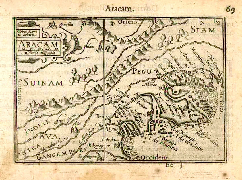
Aracam. c. 1600
Arakan and Pegu by Barent Langenes & Cornelis Claesz
[Item number: 26936]
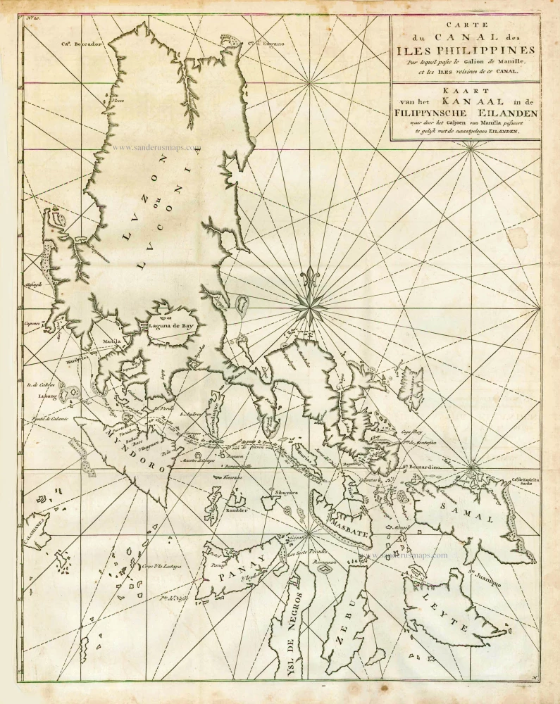
Carte du Canal des Iles Philippines par lequel Passe le Galion de Manille et les Iles Voisines de ce Canal. - Kaart van het Kanaal in de Filippynsche Eilanden waar door het Galjoen van Manilla passeert, tegelijk met de naast gelegen Eilanden. 1748
The Philippines, by George Anson.
[Item number: 27036]
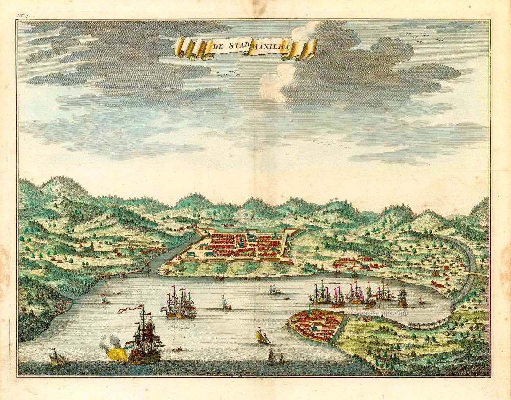
De Stad Manilha. 1724-26
Philippines - Manilla by François Valentyn (Valentijn)
[Item number: 27064]