
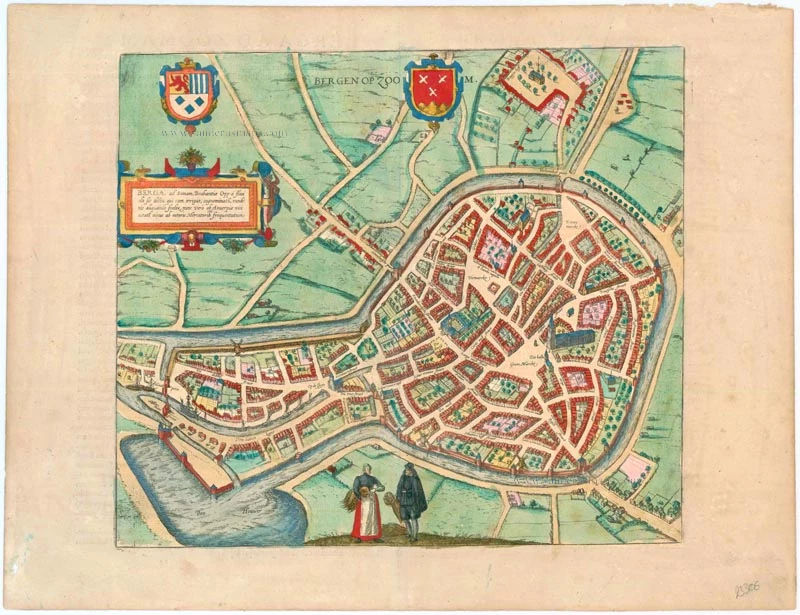
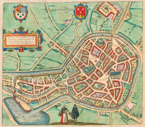
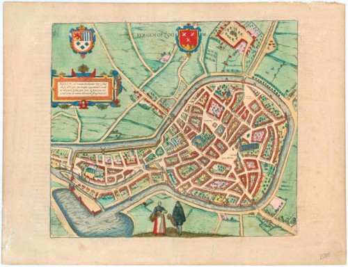
Bergen-op-Zoom, by Georg Braun and Frans Hogenberg. 1581-88

Braun G. & Hogenberg F. and the Civitates Orbis Terrarum.
The Civitates Orbis Terrarum, or the "Braun & Hogenberg", is a six-volume town atlas and the most excellent book of town views and plans ever published: 363 engravings, sometimes beautifully coloured. It was one of the best-selling works in the last quarter of the 16th century. Georg Braun wrote the text accompanying the plans and views on the verso. Many plates were engraved after the original drawings of a professional artist, a professional artist, Joris Hoefnagel (1542-1600). The first volume was published in Latin in 1572, and the sixth in 1617. Frans Hogenberg created the tables for volumes I through IV, and Simon van den Neuwel made those for volumes V and VI. Other contributors were cartographers Daniel Freese and Heinrich Rantzau. Works by Jacob van Deventer, Sebastian Münster, and Johannes Stumpf were also used. Translations appeared in German and French.
Following the original publication of Volume 1 of the Civitates in 1572, seven further editions of 1575, 1577, 1582, 1588, 1593, 1599 and 1612 can be identified. Vol.2, first issued in 1575, was followed by further editions in 1597 and 1612. The subsequent volumes appeared in 1581, 1588, 1593, 1599 and 1606. The German translation of the first volume appeared from 1574 on, and the French edition from 1575 on.
Several printers were involved: Theodor Graminaeus, Heinrich von Aich, Gottfried von Kempen, Johannis Sinniger, Bertram Buchholtz and Peter von Brachel, who all worked in Cologne.
Georg Braun (1541-1622)
Georg Braun was born in Cologne in 1541. After his studies in Cologne, he entered the Jesuit Order as a novice. 1561, he obtained his bachelor's degree, and in 1562, he received his Magister Artium. Although he left the Jesuit Order, he studied theology, gaining a licentiate in theology.
Frans Hogenberg (1535-1590)
Frans Hogenberg was a Flemish and German painter, engraver, and mapmaker. He was born in Mechelen as the son of Nicolaas Hogenberg.
By the end of the 1560s, Frans Hogenberg was employed upon Abraham Ortelius's Theatrum Orbis Terrarum, published in 1570; he is named an engraver of numerous maps. In 1568, he was banned from Antwerp by the Duke of Alva and travelled to London, where he stayed a few years before emigrating to Cologne. He immediately embarked on his two most important works, the Civitates, published in 1572 and the Geschichtsblätter, which appeared in several series from 1569 until about 1587.
Thanks to large-scale projects like the Geschichtsblätter and the Civitates, Hogenberg's social circumstances improved with each passing year. He died as a wealthy man in Cologne in 1590.
Bergen op Zoom - Berga, ad Somam, Brabantiae Opp: a fluvi olo sic dicto, ...
Item Number: 23306 Authenticity Guarantee
Category: Antique maps > Europe > The Netherlands - Cities
Antique map - bird's-eye view plan of Bergen-op-Zoom b y Braun and Hogenberg.
TRANSLATION OF CARTOUCHE TEXT: Bergen op Zoom, Brabantine town, named after the little River Soma (Zoom), which supplies it with water. It was once prosperous on account of its fairs; today, however, due to its proximity to Antwerp, foreign merchants visit the city less.
COMMENTARY BY BRAUN: "Bergen is a beautiful and very well-built town that lies on a small hill in the western part of Brabant, so close to the sea that it could also be called a coastal town. It still has a sizeable population but was much wealthier in earlier times, when the large annual fairs that brought it many benefits and freedoms were still held there."
Bergen op Zoom, which arose in the Middle Ages out of the fusion of three small settlements on the Oosterschelde and was officially chartered in 1347, is seen here in a bird's-eye view. The town plan features three market squares, namely the main market, the fish market and the corn market. Also prominent in the circular historical centre is the basilica of Sint-Lambert. With its harbour (left) and fairs, the former fishing village of Bergen op Zoom rivalled Antwerp, situated to the south, as an important centre of trade up to the beginning of the 16th century. Not until flooding in the hinterland and the Eighty Years' War (1568-1648) did the town go into decline. In 1577, as part of the Dutch Revolt, Bergen op Zoom was taken by the Dutch and successfully defended multiple times against attempts to recapture it by Spanish troops. Today the city has 65,000 inhabitants.
The engraving has been made after a design by Jacob van Deventer.
Date of the first edition: 1581
Date of this map: 1588
Copper engraving
Size: 34 x 38.5cm (13.3 x 15 inches)
Verso text: Latin
Condition: Small tear repaired at top right, running 15 mm into the picture, superb old colour.
Condition Rating: A
References: Van der Krogt 4, 442; Taschen, Braun and Hogenberg, p.222.
From: Civitates Orbis Terrarum. . Liber tertius. Köln, G. Kempen, 1581-88. (Koeman, B&H3)
Braun G. & Hogenberg F. and the Civitates Orbis Terrarum.
The Civitates Orbis Terrarum, or the "Braun & Hogenberg", is a six-volume town atlas and the most excellent book of town views and plans ever published: 363 engravings, sometimes beautifully coloured. It was one of the best-selling works in the last quarter of the 16th century. Georg Braun wrote the text accompanying the plans and views on the verso. Many plates were engraved after the original drawings of a professional artist, a professional artist, Joris Hoefnagel (1542-1600). The first volume was published in Latin in 1572, and the sixth in 1617. Frans Hogenberg created the tables for volumes I through IV, and Simon van den Neuwel made those for volumes V and VI. Other contributors were cartographers Daniel Freese and Heinrich Rantzau. Works by Jacob van Deventer, Sebastian Münster, and Johannes Stumpf were also used. Translations appeared in German and French.
Following the original publication of Volume 1 of the Civitates in 1572, seven further editions of 1575, 1577, 1582, 1588, 1593, 1599 and 1612 can be identified. Vol.2, first issued in 1575, was followed by further editions in 1597 and 1612. The subsequent volumes appeared in 1581, 1588, 1593, 1599 and 1606. The German translation of the first volume appeared from 1574 on, and the French edition from 1575 on.
Several printers were involved: Theodor Graminaeus, Heinrich von Aich, Gottfried von Kempen, Johannis Sinniger, Bertram Buchholtz and Peter von Brachel, who all worked in Cologne.
Georg Braun (1541-1622)
Georg Braun was born in Cologne in 1541. After his studies in Cologne, he entered the Jesuit Order as a novice. 1561, he obtained his bachelor's degree, and in 1562, he received his Magister Artium. Although he left the Jesuit Order, he studied theology, gaining a licentiate in theology.
Frans Hogenberg (1535-1590)
Frans Hogenberg was a Flemish and German painter, engraver, and mapmaker. He was born in Mechelen as the son of Nicolaas Hogenberg.
By the end of the 1560s, Frans Hogenberg was employed upon Abraham Ortelius's Theatrum Orbis Terrarum, published in 1570; he is named an engraver of numerous maps. In 1568, he was banned from Antwerp by the Duke of Alva and travelled to London, where he stayed a few years before emigrating to Cologne. He immediately embarked on his two most important works, the Civitates, published in 1572 and the Geschichtsblätter, which appeared in several series from 1569 until about 1587.
Thanks to large-scale projects like the Geschichtsblätter and the Civitates, Hogenberg's social circumstances improved with each passing year. He died as a wealthy man in Cologne in 1590.
Related items
Nymmegen - Noviomagium sive Nouiomagum vulgo Nijmmegen inclyta quoda Francorum Regia Urbs Gelriae primaria. 1582
Nijmegen, by Braun & Hogenberg.
[Item number: 14229]

Urbis Campensis ad Isalam Fluvium Icon. 1581-88
Kampen, by Georg Braun and Frans Hogenberg.
[Item number: 22215]

Roterodamum. 1588-97
Rotterdam, by Georg Braun and Frans Hogenberg.
[Item number: 22257]
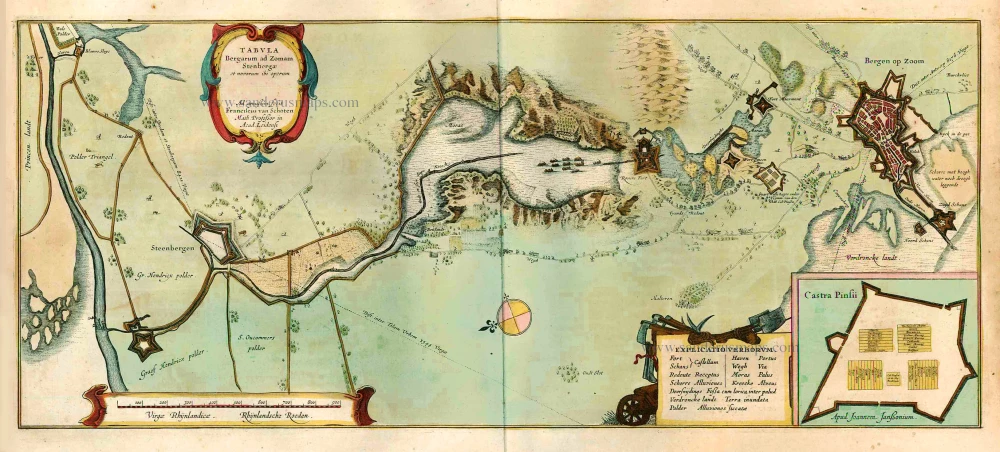
Tabula Bergarum ad Zomam Stenbergae et novorum ibi operum. 1640
Vicinity of Bergen-op-Zoom by Willem Blaeu.
[Item number: 22495]
Bergen op Zoom. 1656
Bergen op Zoom, by Visscher N. - Schut P.H.
[Item number: 25374]
Tabula Bergarum ad Zomam Sternbergae et novorum ibi operum. 1641
Bergen-op-Zoom, by J. Janssonius.
[Item number: 26307]
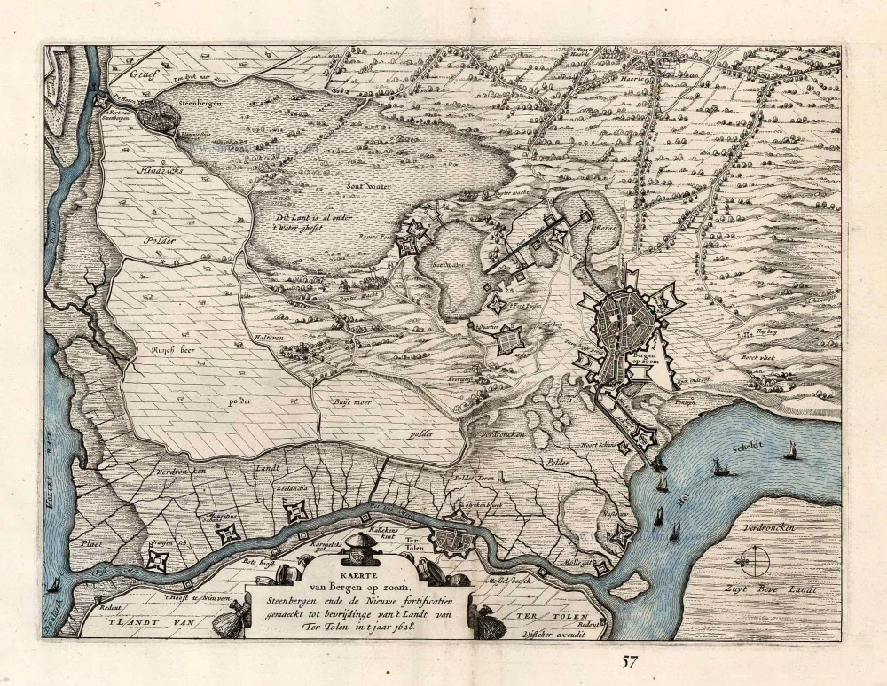
Kaerte van Bergen op Zoom. Steenbergen ende de Nieuwe fortificatien gemaeckt tot bevrijdinge van 't Landt van Ter Tolen in t jaar 1628. 1630
Bergen op Zoom, by Visscher C.J. - Janssonius J.
[Item number: 26344]
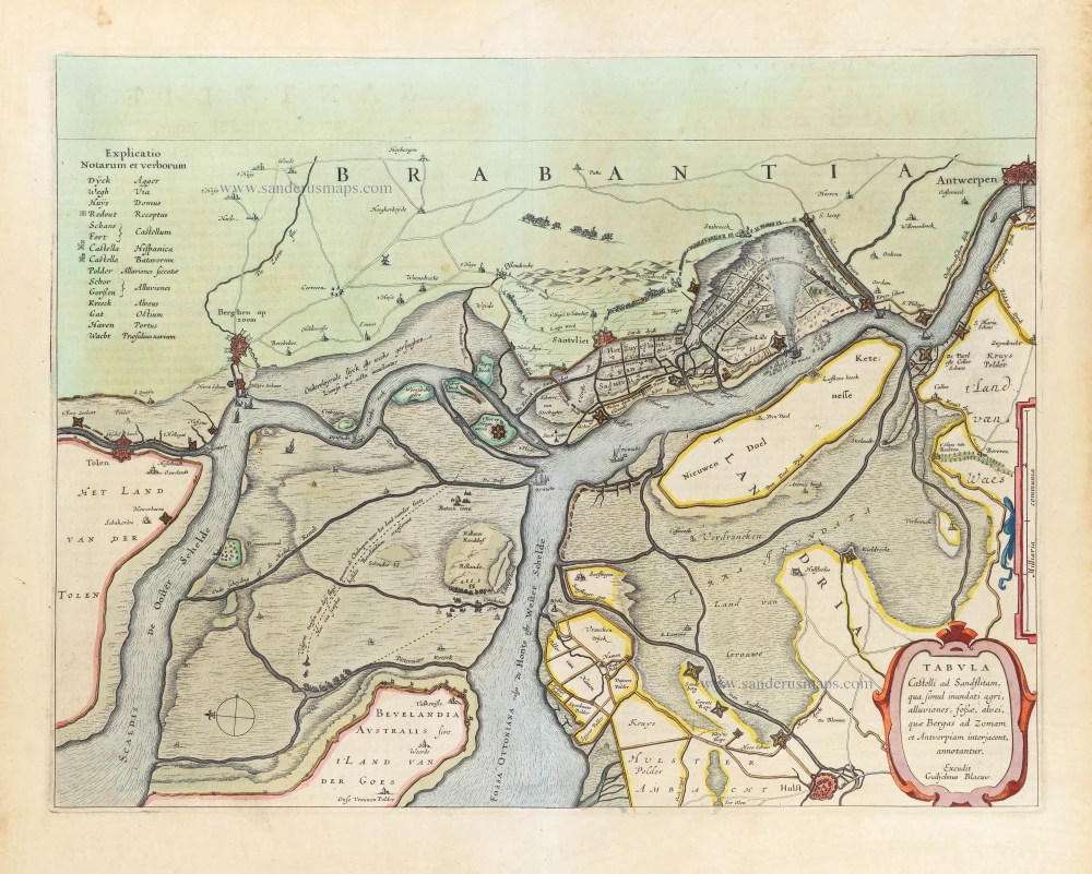
Tabula Castelli Ad Sandflitam, qua simul inundati agri, alluviones, fossae, alvei, quae Bergas ad Zomam et Antverpiam interjacent, annotantur. 1643
Bergen-op-Zoom - Zandvliet, by Willem Blaeu.
[Item number: 29333]