
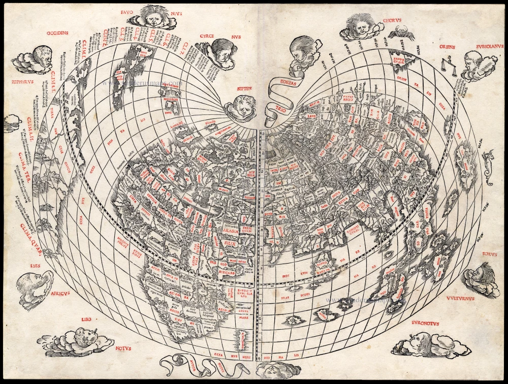
Antique map of World by Sylvanus Bernard 1511

No title
Item Number: 22606 Authenticity Guarantee
Category: Antique maps > World and Polar
This large cordiform modern world map, published in the first Venetian edition of Ptolemy, is only the second map in a Ptolemaic atlas to show America and the first western printed map to indicate Japan.
"The capital letters are printed in red by means of type set into the woodblocks which, together with the decorative windheads, zodiacal signs, and distinctive heart-shaped projection, make this a most striking representation. ... Sylvanus' map was not reprinted and hence remains relatively scarce. His new heart-shaped projection was however adapted by several later cartographers and used for a number of important maps throughout the sixteenth century". (Shirley)
Woodcut, printed in red and black on two sheets, joined.
Size: 42.5 x 56cm (16.5 x 21.9 inches)
Verso: Blank
Condition: Trimmed at lower margin (2 mm), two small repairs at outer edge. Nice copy.
Condition Rating: B+
References: Shirley (World), 32; Karrow, 75/55.
From: Claudii Ptolemaei Alexandrini liber geographiae cum tabulis . . . cim additione locorum quae a recentioribus reperta . . . Venice, 1511.
This atlas was the first of many editions of Ptolemy to be printed in Venice. It was the first Italian edition to use woodcut rather than copper engraved maps and the first atlas printed in black and red.